Peru - Cusco and its surroundings
- Cusco and its surroundings
- The Sacred Valley
- Waqrapukara
- Salkantay trek and Machu Picchu
- Ausangate
- Practical Information (2025 prices)
We arrived in Cusco by night bus from Arequipa in the middle of September. Tickets for Machu Picchu must be bought well in advance, and since ours were booked for the beginning of October, we knew we had just over two weeks to explore the city and its surroundings. This turned out to be a perfect amount of time to comfortably see most of what this region has to offer.
We divided our exploration into several areas:
- Cusco and the Sacred Valley: Dozens of sites, most requiring the Boleto Turístico Cusco (BTC).
- Waqrapukara: A lesser-known but stunning Inca fortress requiring a beautiful trek.
- Salkantay Trek: A multi-day journey leading to Machu Picchu.
- Ausangate Region: Palcoyo Rainbow Mountain and the Seven Lagoons circuit.
Intro Hostels became our base in Cusco. We originally chose it because of its affordable price and our desire for a more “social” atmosphere, so we could chat with other travelers and get fresh, first-hand information. In the end, however, we liked it so much that we kept returning there throughout our entire stay. There were several reasons for this: a decent breakfast, a nice outdoor terrace with tea available all day, a great location, and also the staff and volunteers, whom we already knew by name. It wasn’t exactly luxury, but it was enough for our needs. A huge plus was also the possibility to leave our luggage stored there while we were away on a trek. By the time we were returning for the fifth time and had to fill out the same accommodation form again, the receptionists already knew our names and were making a bit of fun of us.
Cusco and its surroundings
We began our exploration of Cusco on the second day, as soon as we managed to catch up on the sleep deficit from the night bus. We started with a classic – a free walking tour (with the Incan Milky Way company), which was incredibly useful and gave us a great orientation of the whole city.
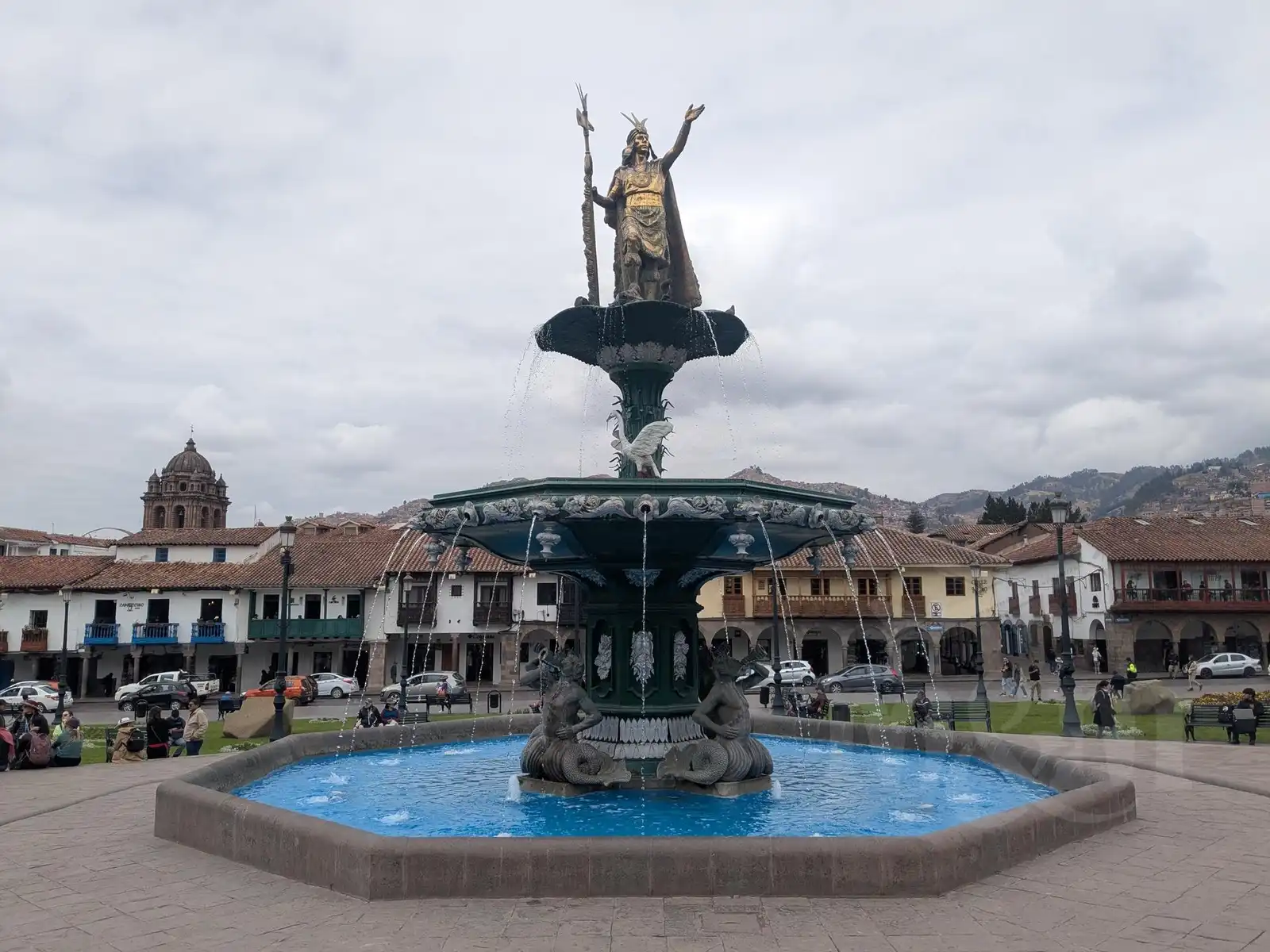
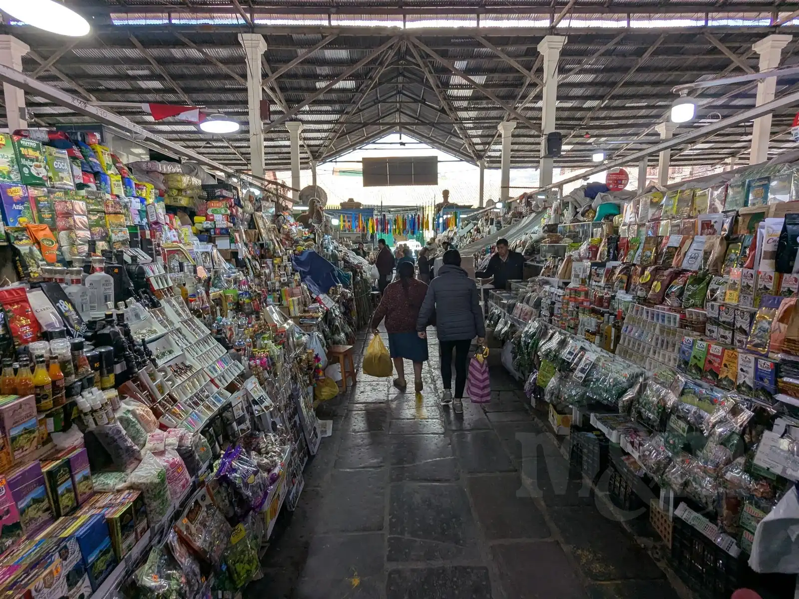
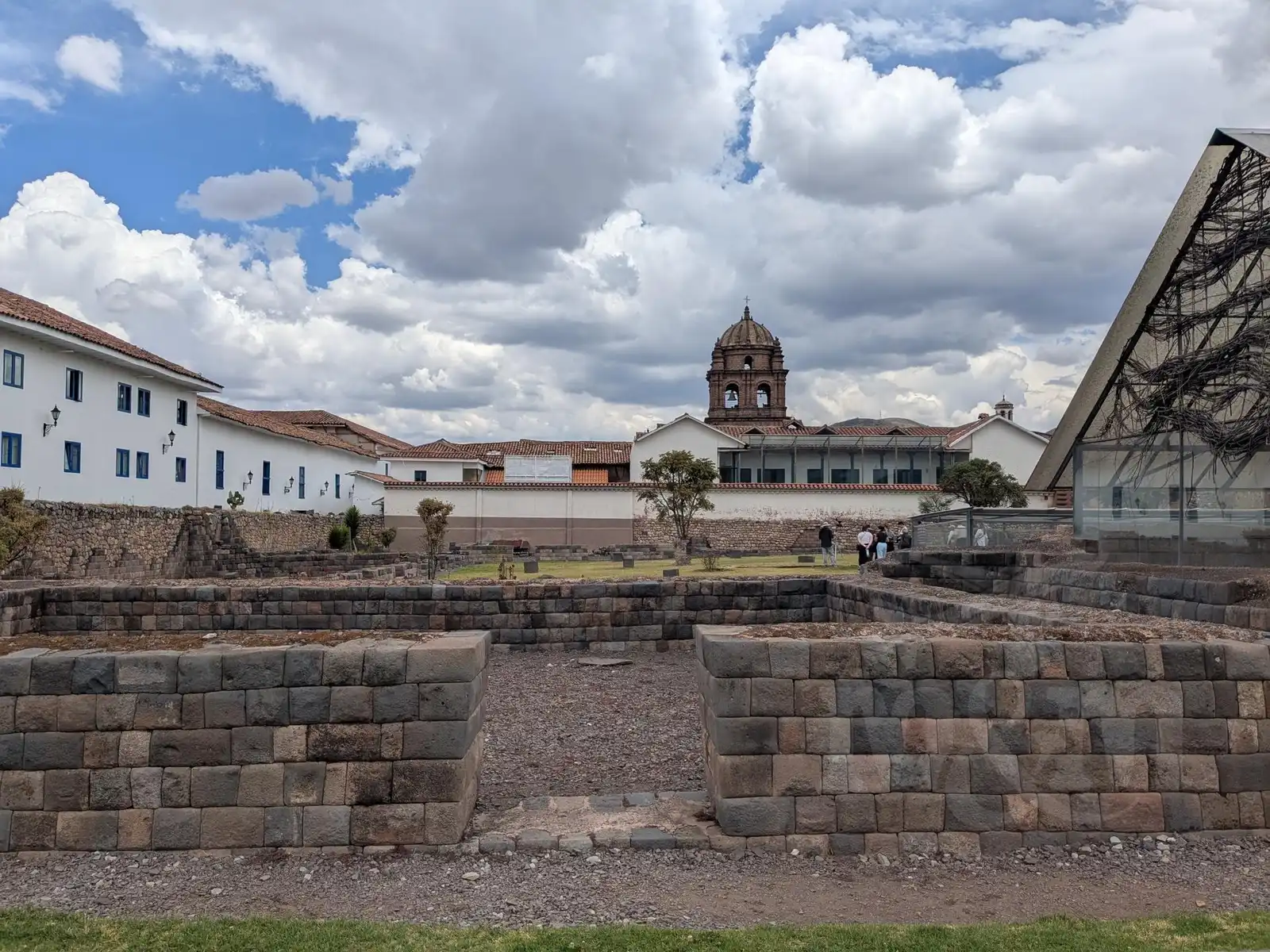
We visited the Mercado Central de San Pedro, which is an architecturally quite unique building. It was designed by Gustave Eiffel himself, but local legend claims that due to the high altitude, he didn’t exactly feel at his best, and it turned out the way it did. Our steps also led us to the main square, where Francisco Pizarro once declared the conquest of the Inca Empire, and to the freely accessible ruins of the Kusicancha palace. Unfortunately, not many original Inca monuments remain in Cusco itself – after conquering the city, the Spaniards systematically demolished Inca temples and built their churches on their foundations. Essentially, one could say that almost every church in the city today stands on a site where an Inca temple used to be.
The centerpiece of today’s city is rather the aforementioned Mercado de San Pedro. You can get absolutely everything here: from clothing to fresh meat and cheeses to fragrant pastries. But the best part is the section with “restaurants” – miniature stalls where huge pots bubble on gas stoves. We liked one particular stand where they made great trout and arroz a la cubana. Moreover, the market flows seamlessly into the surrounding streets, where everything else that didn’t fit into the building is sold.
In Cusco, we also bought the ten-day Boleto Turístico Cusco (BTC) ticket, which serves as an entry ticket to most monuments (16 sites) around Cusco. At 130 PEN (cheaper for Magda, as she still managed to pass as a student with her ISIC card), it is quite expensive by local standards, but considering the number of monuments it includes, in hindsight, it seems like a good deal. It is quite surprising that, at least here, they managed to reach an agreement and create one joint ticket for multiple sites – that is definitely not common in Peru.
There are not many archaeological sites directly in the city; the BTC here applies mostly to museums. We visited three:
- Museo Histórico Regional: An introduction to the history of Peru and the Inca Empire, which helped us put names and events into context. Unfortunately, the English descriptions are not great.
- Monumento a Pachacuteq: A tower with an exhibition about the most significant Inca ruler.
- Museo de Sitio Qorikancha: An exhibition of excavations from the most famous Sun Temple. Unfortunately, entry to the (upper) Qorikancha temple itself is not included in the BTC and must be paid separately.
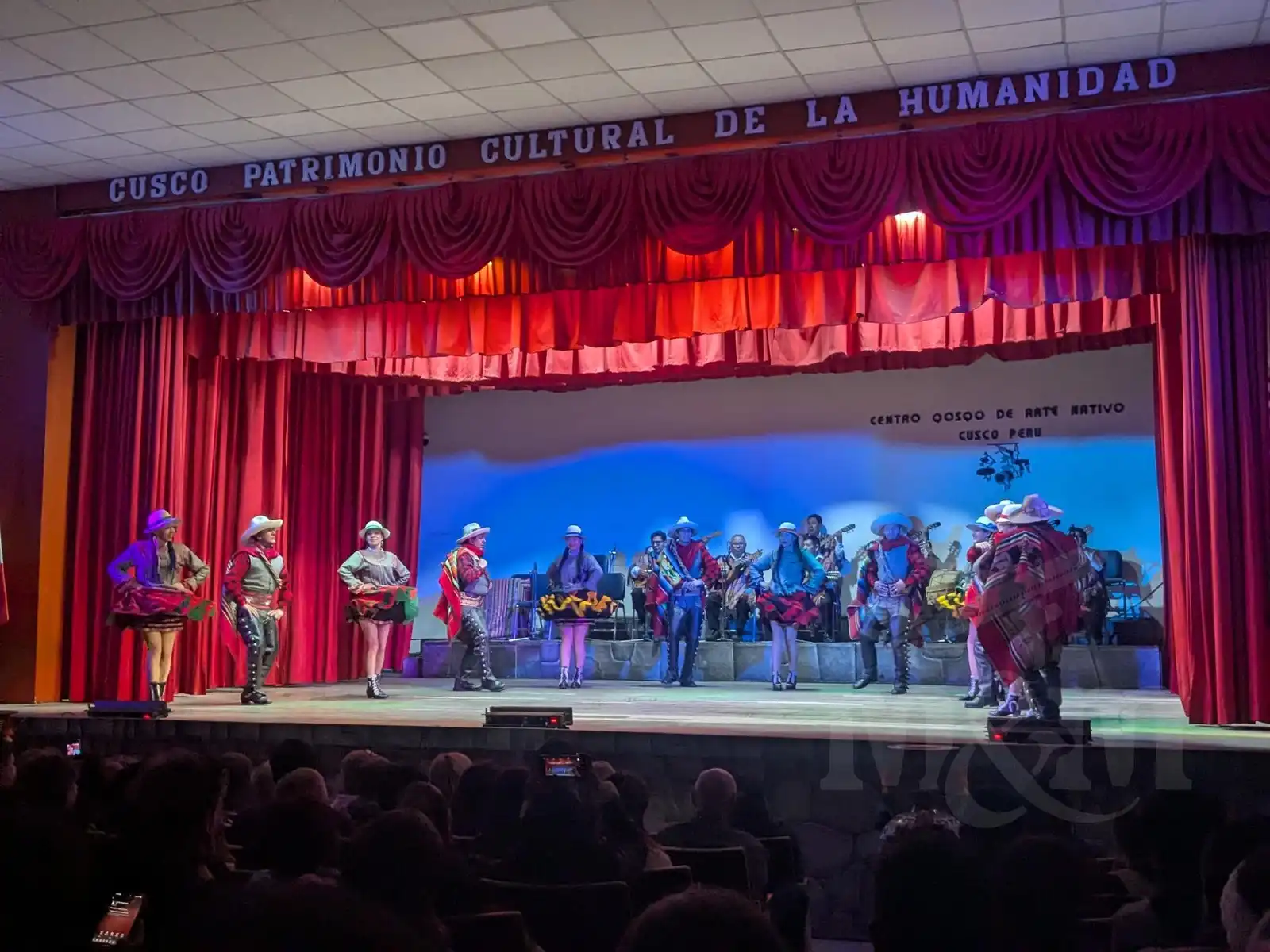
On our last evening in Cusco, we managed to catch a folklore performance at the Centro Qosqo de Arte Nativo, which is also included in the BTC. Seeing the local dances and costumes was a pleasant change of pace.
The Sacred Valley
The Sacred Valley stretches along the Urubamba River. At its eastern end lies Pisac and at its western end Ollantaytambo – two significant Inca settlements that once guarded this fertile valley. If we were to continue further west against the current of the river, we would reach Machu Picchu. However, the road ends after Ollantaytambo, and from there, only the railway line continues, used by tourist (and very expensive) trains.
Pisac
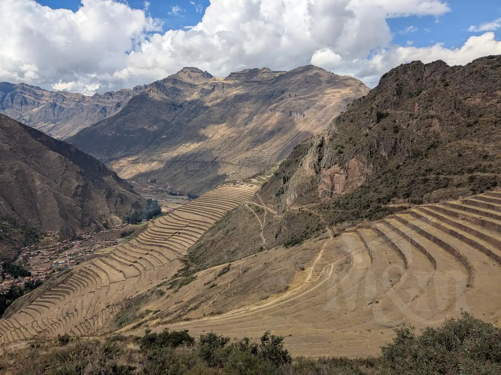
Getting from Cusco to Pisac is a piece of cake. Just hop into a colectivo (shared van) departing from Puputi Street. The journey takes less than an hour and costs only 5 PEN per person. Since we arrived in the afternoon, we only had time to walk through the town with its famous market and saved the visit to the monuments themselves for the next day. The plan was clear: be there as early as possible to beat the crowds of tourists who usually arrive on day tours from Cusco between nine and ten in the morning.
In the morning, however, we realized it wouldn’t be that simple. The Inca ruins are spread high up on the hill, and the best views are at the very top – where the tour buses comfortably drive. If we wanted to go on foot from the town and be at the top before ten, we would have had to set off at maybe six in the morning. That was out of the question after a seven o’clock alarm. After weighing our options, we decided on a taxi. In such a small town, apps don’t work, so there was nothing left to do but wave at passing cars and bargain. In the end, we negotiated 30 PEN. It wasn’t exactly a great deal (considering the journey from Cusco cost a fifth of that), but we simply didn’t feel like climbing up that steep slope.
Thanks to the taxi, however, we truly beat most of the tour groups and for a while had the view of the terraces carved into the slopes almost to ourselves. When we saw the crowds that arrived after nine, we certainly didn’t regret it. The entire site is divided into several levels with house ruins, connected by rather steep paths and stairs. The Temple of the Sun in the middle section is particularly beautiful and strongly reminiscent of iconic views of Machu Picchu.
During our descent, dark cloud appeared, and towards the end, a proper rain started. The rain soon turned into hail and lasted for nearly an hour. Fortunately, we managed to hide under the roof of a grilled chicken restaurant. I wouldn’t have wanted to be in the shoes of those who had to descend those slippery stone stairs in that hailstorm (we even saw tourists in flip-flops; it must have been quite an experience for them).
When the rain stopped, we emerged from our hiding place and caught another colectivo to our next stop – Urubamba. We had accommodation booked there, which served as our base for a trip to Moray and the salt mines in Maras.
Urubamba, Moray, Salineras de Maras
Urubamba is a very pleasant town with a huge fruit market where we treated ourselves to an absolutely luxurious mango-pineapple juice. Additionally, we found great and cheap accommodation here – although it had a shared bathroom, we were completely alone in the whole house 😀.
The next day, our plans got a bit complicated because Magda wasn’t feeling well in the morning. Eventually, she decided to stay in bed, so I set off on the expedition toward Maras and Moray alone.
From the terminal in Urubamba, colectivos go directly to the village of Maras. I found the van easily, but then came a test of patience. Not many tourists travel this route, mostly just locals going to the markets, so I waited for almost an hour before the car filled up and we finally set off. An alternative would have been to catch a more frequent connection to Cusco, get dropped off at the Maras intersection, and walk the remaining 4 km to the village, but I didn’t feel like doing that.
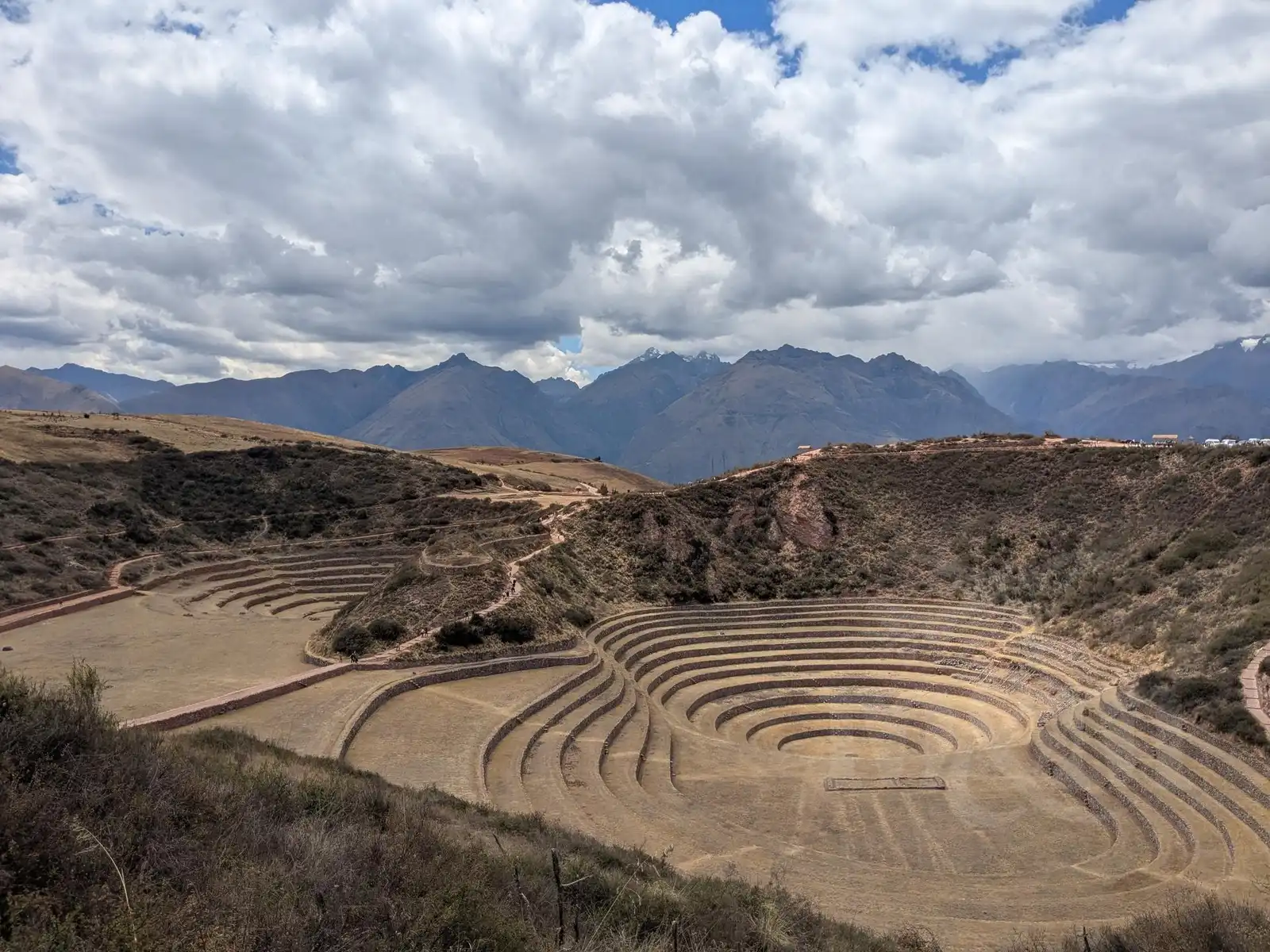
The van dropped me off at a charming square in Maras. It was another 5 km to the Moray Inca terraces. There were taxis standing at the square, but I didn’t want to pay for them when I was alone, so I began walking. It’s quite a nice walk, and I didn’t meet a single soul until I reached the junction with the main road to Moray.
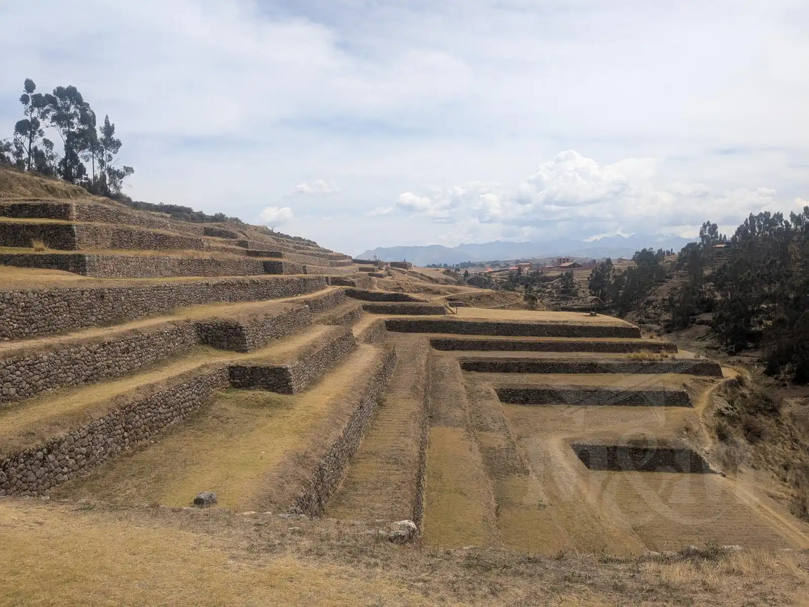
Moray itself is visually stunning, though quite small. It consists of three giant depressions in the ground, lined with terraces around the perimeter. The Incas reportedly used this place as an agricultural laboratory. Thanks to their construction, the terraces retained water, and the stone walls heated up during the day so that they radiated heat at night, preventing the soil from freezing. This allowed the Incas to cultivate crops that normally wouldn’t survive at these altitudes. The entire site can be walked around via several trails, and even with frequent photo stops, I had it completely explored in an hour.
I didn’t feel like walking back to Maras in the midday heat, so I decided to try my luck hitchhiking. I stood by the roadside and hesitantly raised my thumb when the first passenger car passed (I assumed the previous tourist vans wouldn’t take me). To my surprise, the very first car stopped! It was a Peruvian family on a trip. With my very basic Spanish, we didn’t chat much, but at least I helped them a bit with navigation. The head of the family decided to take a “shortcut” – via the dirt paths where I had walked before. On the unmarked roads, however, they got a bit lost. It was a good thing I had offline mapy.cz on my phone, so I could navigate from the back. Since I didn’t know the Spanish words for right and left, I had to just point with my hands.
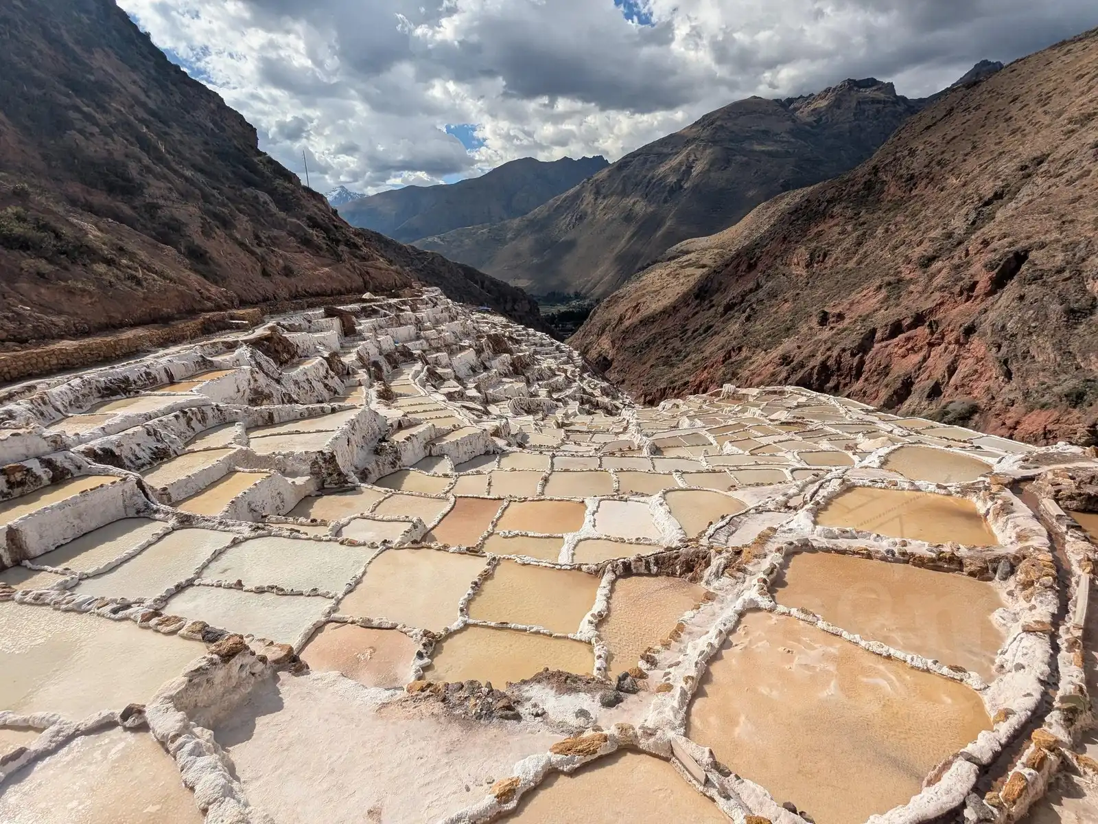
They dropped me off at the edge of the village, where I grabbed a quick lunch menu for 8 PEN (the cheapest in Peru), and then continued to the famous Salineras de Maras. The path from the village leads downhill and is well-marked. The first view of the salt fields from above is absolutely breathtaking. I was a bit annoyed, though, that you have to pay admission even for just the viewpoint (you are no longer allowed directly between the salt ponds because tourists were leaving trash there), so I bypassed the collector’s booth via an inconspicuous back path. I wasn’t in the mood to pay just for a view from a hill. I guess I wasn’t the only one; it was a well-trodden path.
I continued along the trail, passed a warehouse with thousands of bags of salt, and finally descended all the way to the village of Pichingoto. From there, it was just a short walk across the Urubamba River to the main road. There, I waved at the first passing colectivo, which took me back for just 2 PEN.
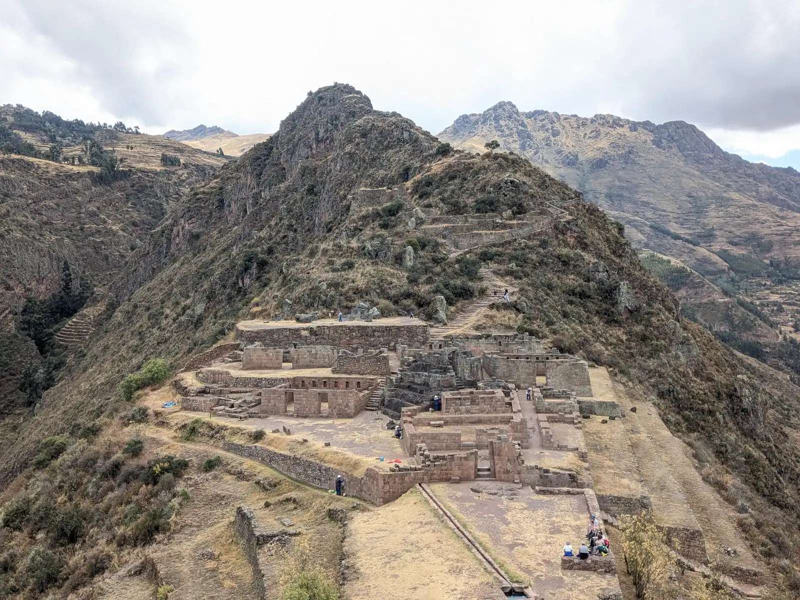
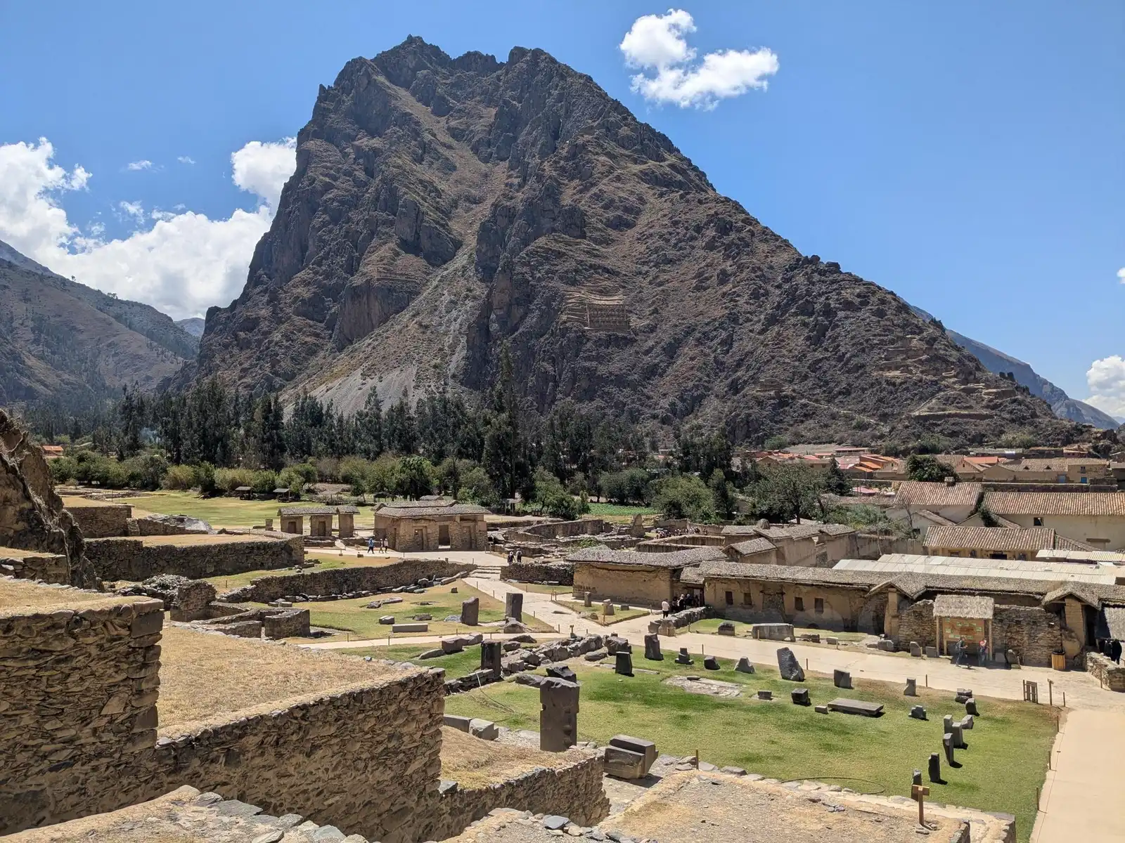
Ollantaytambo
The next day I set off for Ollantaytambo – again alone, because Magda still wasn’t feeling quite right. There are tons of colectivos going there from Urubamba, so transportation was perfectly fine. This time, no long walk awaited me either, as the van stops right in the town, from where it’s only a few hundred meters to the entrance of the site.
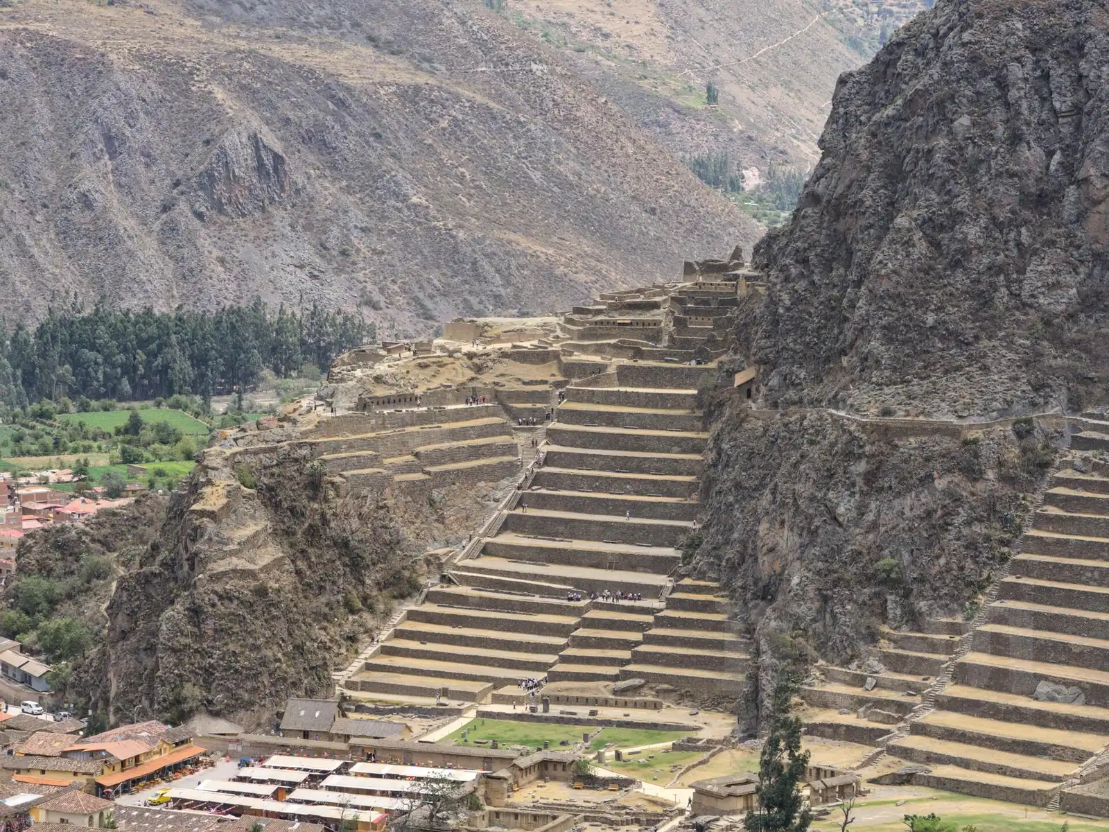
The Inca ruins rise on a steep slope right on the edge of the village. At the bottom, you’ll find the Temple of Water and the remains of several houses, while llamas graze lazily on the lawns. You can then climb the massive stone terraces up to the Temple of the Sun. For those who still have enough strength, there’s a hike to a viewpoint that offers a magnificent view of the river and the entire surroundings. Naturally, I didn’t skip anything. After leaving the site, I also hiked up to the granaries on the opposite slope – it’s a bit of a climb, but the view of the entire fortress from the other side is definitely worth it.
The restaurants directly around the square are typical tourist traps with quite inflated prices. You only need to walk a street further to the local market (mercado), where you’ll find establishments for locals. I had a classic menu del día there for 10 PEN and returned by colectivo to Urubamba with a full stomach.
Chinchero
The next day, Magda finally felt better, so we decided to end our several-times-extended stay in Urubamba and head back to Cusco. However, Chinchero lies directly on the route and is also included in the BTC ticket, so we decided to stop there for a while.
Chinchero lies another few hundred meters higher than Cusco, which we felt immediately during the walk up from the colectivo stop. The main archaeological site with Inca terraces and walls isn’t one of the most extensive, and you can walk through it in less than an hour. Above the terraces stands a colonial church built – as is tradition in Peru – directly on the foundations of an Inca palace. It’s supposed to be beautifully decorated, but we didn’t get inside; unfortunately, it was closed.
We also unexpectedly ran into a group of Czechs here who were there with a travel agency. After a long time in Peru, it was quite unusual to hear someone else speaking Czech.
From Chinchero, we then caught our last colectivo towards Cusco, where we returned once again to our familiar Intro Hostel. We were ready for the next adventure.
Tambomachay, Puma Pukara, Qenqo and Saqsaywaman
These four monuments are located in the hills directly above Cusco and can be comfortably managed in a single day. Strategically, we took a colectivo up to the furthest one, Tambomachay, and then gradually returned towards the city on foot.
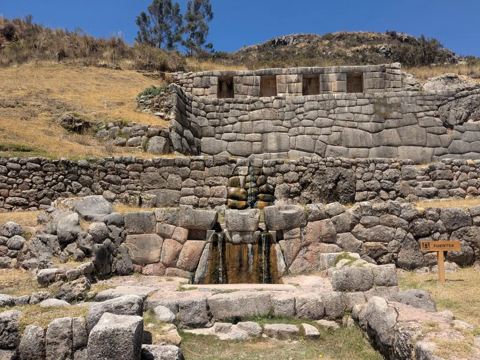
Tambomachay is essentially a sanctuary of water. It is a precise Inca structure with channels and small waterfalls that still function today. Apart from the structure itself and a few views of the surroundings, there isn’t much else to see here, so the tour didn’t take us much time.
Just a few hundred meters further (towards Cusco) lies Puka Pukara. It is a military fortress on an elevated hill that served to guard the access to the empire’s capital. We were lucky and were almost alone in the site at that moment.
For the next stop, the sacred site of Qenqo, we had to walk about four kilometers along the road. Qenqo is basically a large rock permeated with natural tunnels and artificially carved passages. Inside is an altar where, according to legend, rituals were performed and where the body of the ruler Pachacuteq himself was supposed to be placed after death (supposedly, as the mummy itself was never found).
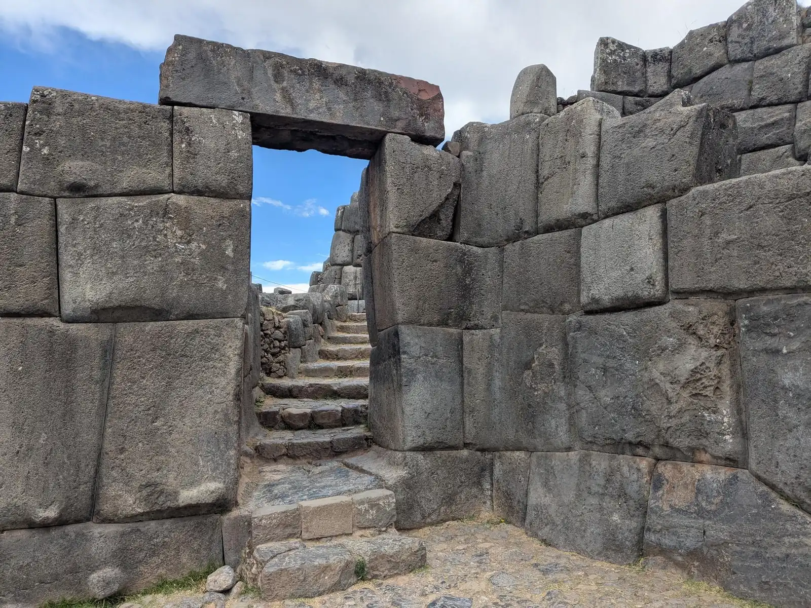
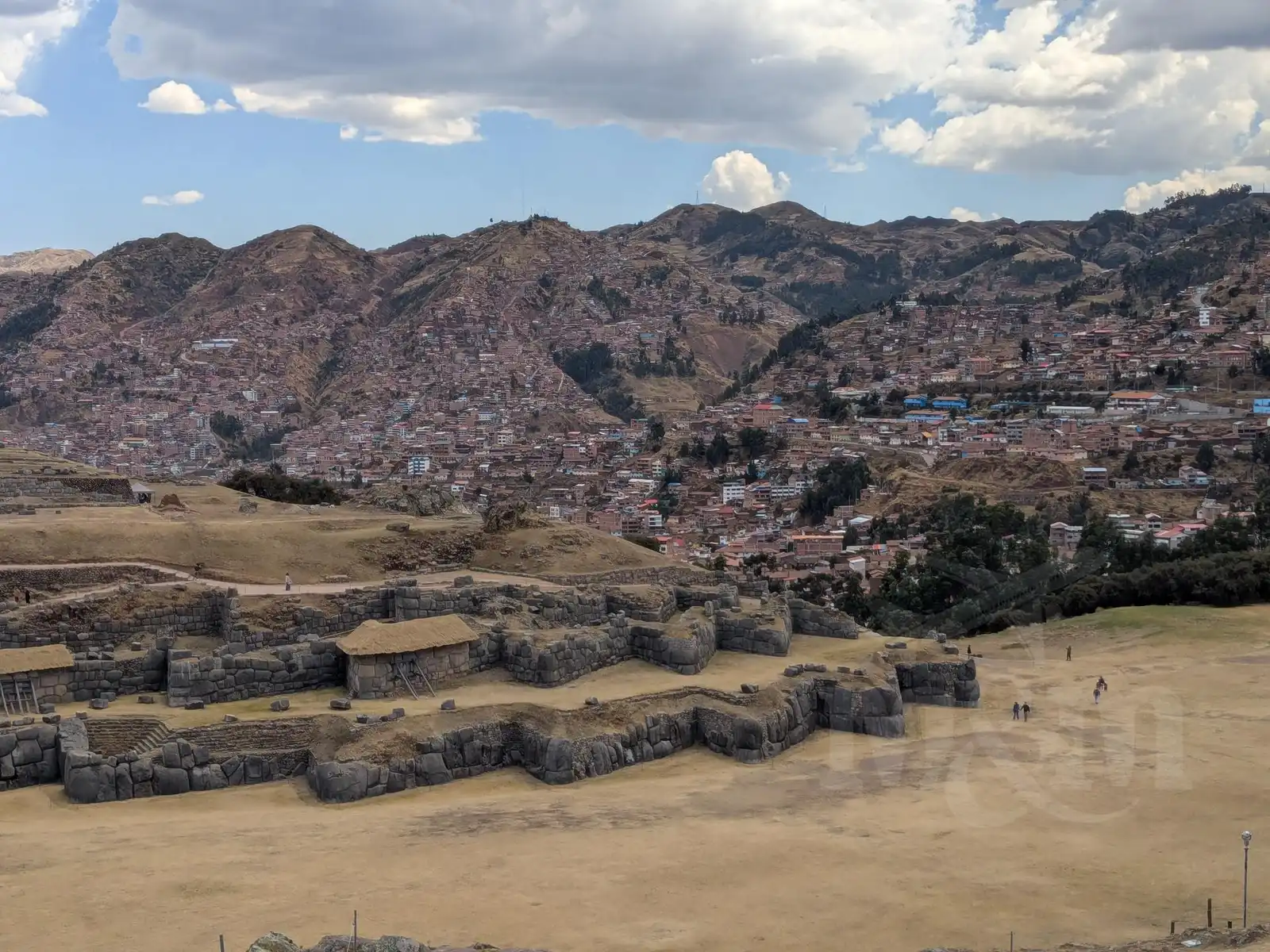
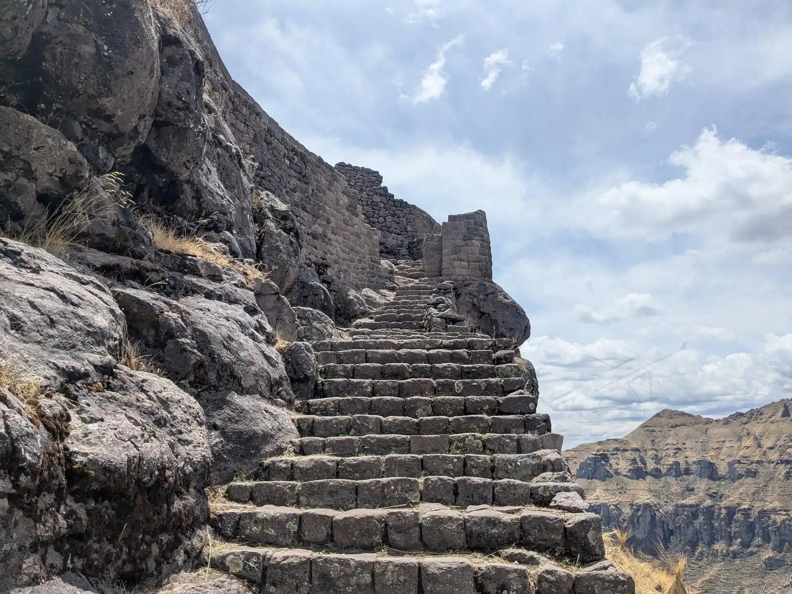
The last and largest in the series was Saqsaywaman. To this day, we aren’t sure of the correct pronunciation in Quechua, but the working name “Sexy Woman” stuck with us the whole time. Saqsaywaman is definitely the most extensive and impressive of these four monuments. While we would describe the previous three places as optional, we definitely recommend not missing this one. It is a massive complex of walls built from incredibly large stone blocks that fit together with amazing precision. To top it all off, it offers a fantastic view of Cusco, where you can see the city at a glance. We left absolutely thrilled.
Waqrapukara
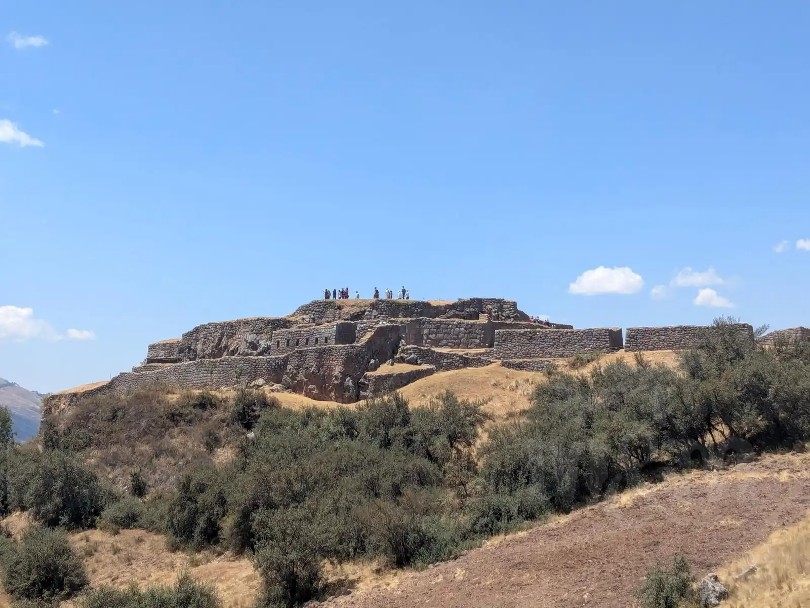
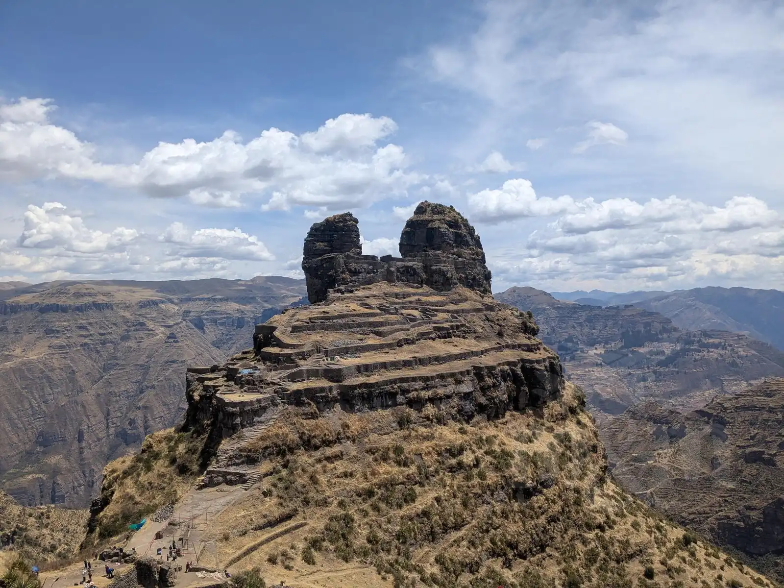
Waqrapukara is an Inca fortress whose name in Quechua literally means “horned fortress.” Most tourists never come across it – we only found out about it during a lecture by Czech traveler Pavel Svoboda. Since we wanted (well, mostly I wanted) a bit of a real adventure without the crowds, we decided to visit it on our own with a tent.
The journey began in Cusco, from where we set off on an Expreso El Zorro bus to the village of Sangarará. When they dropped us off after several hours of driving, we immediately caught the attention of the local police, that is stationed right by the bus stop. Two foreigners with full backpacks clearly don’t show up here every day. They asked us where we were going, and when we said Waqrapukara, the officer was visibly taken aback. He claimed the path was dangerous and that we would certainly get lost. Our assurance that we had offline maps didn’t comfort him much. In the end, he at least wrote down our phone numbers – to this day, we have no idea what use they would be to him in the mountains without a signal. Even though we had read quite a bit about it, he made us feel slightly uncertain, so we followed his advice and took a taxi for the first few kilometers uphill.
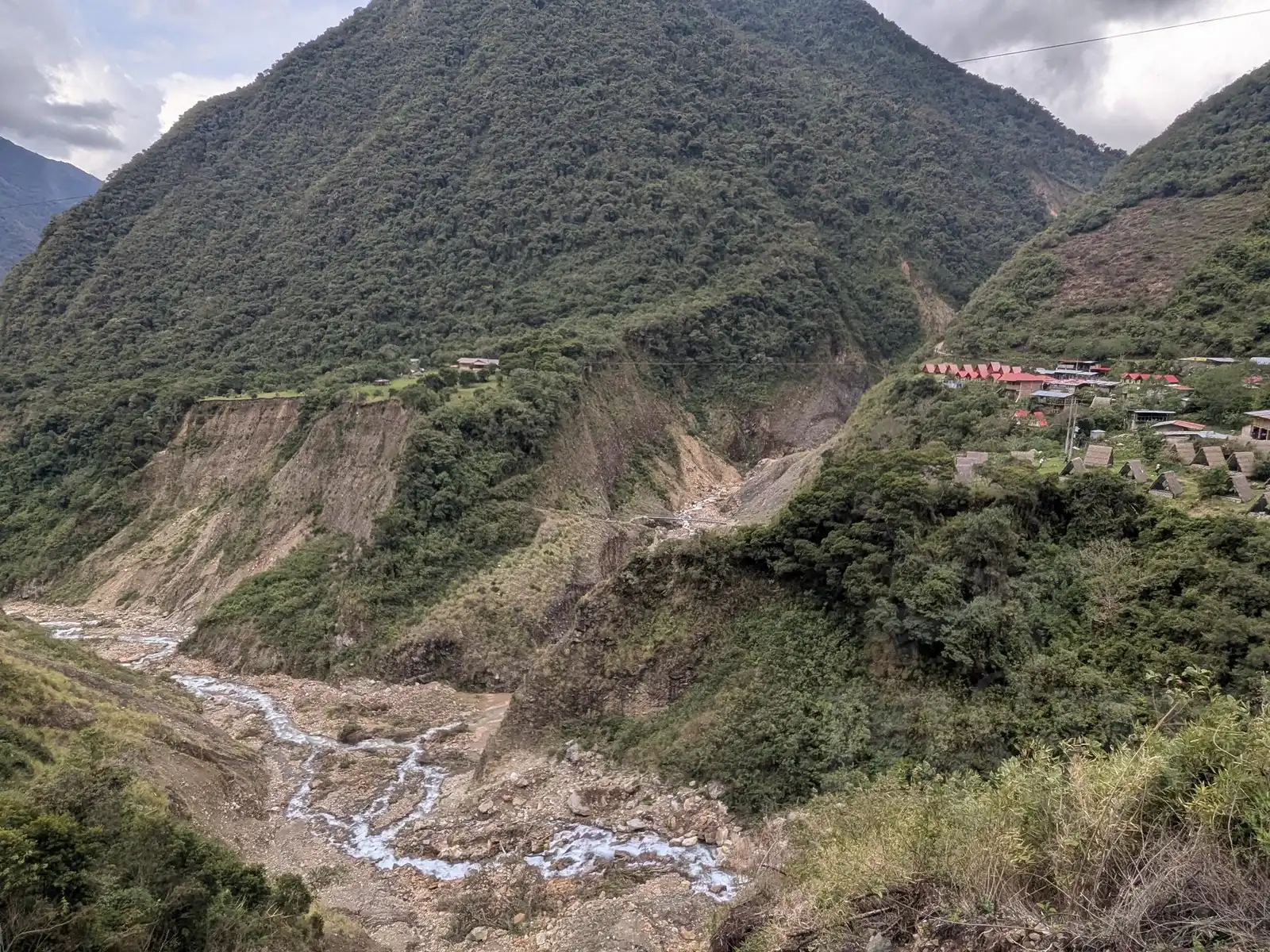
In hindsight, it was unnecessary panic. The path was quite clear and well-marked. At least we saved ourselves the first few kilometers of climbing. From the spot where the taxi dropped us off, we had another 8 kilometers of walking through a beautiful landscape where we didn’t meet a single soul. The fortress itself appeared before us after less than three hours of trekking. The sight is absolutely unique – the fortress sits on top of a rock above the deep canyon of the Apurímac River, and its two rock towers truly look like horns. Inside the complex, we only ran into a group of local children, perhaps on a school trip. The entrance fee was voluntary, which is a very rare in Peru, where you usually pay even for a view from a distance.
However, we arrived there too early to set up our tent, so we decided to continue further along the canyon. The trail offers beautiful views, but as soon as we began descending toward the village of Huayqui, the sky darkened and it looked like a serious storm was coming. A thunderstorm on a steep slope is nothing you’d want to experience, so we basically ran down the hill. Breathless, we reached the edge of the village and set up the tent in record time. The storm eventually missed us, but we stayed anyway and spent a peaceful night there.
The next day, we had to reach the town of Acomayo. The walk along the dusty road wasn’t great, so we wanted to try hitchhiking the first thing that came along. The first car in our direction appeared after an hour and a half. A local farmer willingly stopped, made room for us between sacks of potatoes in the back seats, and picked us up. He was going all the way to Acomayo, so he dropped us right at the bus. Along the way, he explained what grows in the surrounding fields. He also revealed that a hotel is being built near Waqrapukara. If it actually gets finished, it probably won’t be so deserted or have a voluntary entrance fee anymore.
The trip back from Acomayo went smoothly on the same bus line. We returned to Cusco in the evening tired and dusty, but thrilled. For us, Waqrapukara has been one of the strongest experiences in Peru so far.
Salkantay trek and Machu Picchu
When we were planning our trip to Peru, it was clear to us that we couldn’t skip Machu Picchu. Although we usually avoid crowds, seeing one of the “New Wonders of the World” with our own eyes felt like a must. After all the Inca ruins we had already seen, we were a bit sceptical about whether it could still impress us, but we had already bought the tickets before we left Czechia, so there was no turning back.
There is no road to Machu Picchu; it can be reached in several ways:
- By train: The most comfortable and fastest way from Ollantaytambo, but also the most expensive (from 60 USD one way).
- By a combination of minibus and walking: By minibus to the Hidroeléctrica station and then 10 km on foot along the tracks. Cheaper (approx. 15 USD), but time-consuming and uncomfortable (6 hours in a minibus on a very bad road).
- On foot over the mountains: Either the more famous Inca Trail (expensive, with a guide, reservation required months in advance) or the Salkantay Trek, which can be done independently. You can sleep either in a tent or in various categories of accommodation along the way. The final price depends on that.
If you’ve been reading about our journey so far, it must be clear which option we chose. A few days before our entry date, we stood in Cusco with backpacks full of food and a tent at the start of the Salkantay Trek.
Day 1: Humantay Lake and the climb to the Salkantay Pass
Getting to the start is a bit of a puzzle. A colectivo drops you off in Mollepata, from where it’s another 10 km up a steep hill to Soraypampa (the actual start of the trek). However, in the van, we met an Australian girl and a guy from the USA, shared a taxi, and thus saved ourselves the boring stretch along the road.
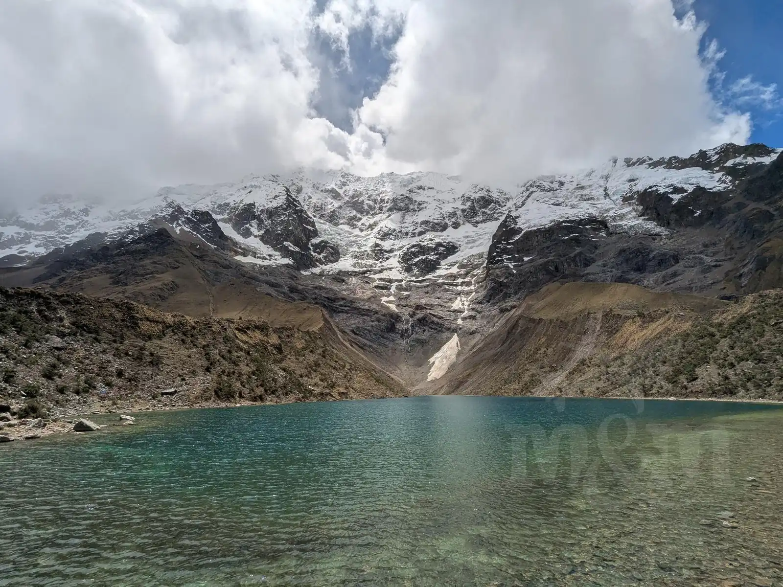
Around noon, we began climbing to Humantay Lake. It is a detour, but the lake with the glacier in the background was supposed to be beautiful, and additionally, we could go without our heavy packs – there is a (paid) storage area at the bottom of the hill. There were crowds of people, but it turned out that most of them only went to the lake and back and didn’t continue on the trek. The lake was nice, but after the lakes we saw in Huaraz, the view didn’t seem quite as breathtaking to us. After returning to our backpacks, we finally set off on the trek itself. While organized groups slept in luxury domes in the valley, we wanted to get a head start. We camped just a few hundred meters below the Salkantay Pass at an altitude of around 4,400 m above sea level.
Day 2: Over the pass and into the jungle
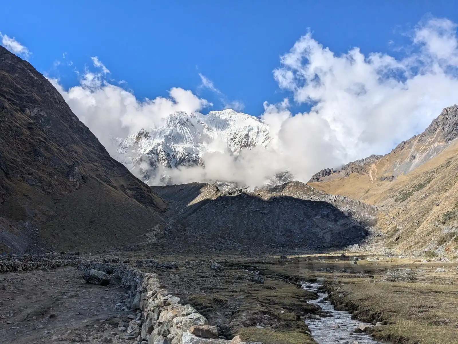
In the morning, the groups that started as early as four o’clock overtook us, but we didn’t mind; we had no reason to rush. After a few demanding hours, we stood at the Salkantay Pass (4,630 m above sea level). Unfortunately, there were no views of the snowy peak – we were in a thick cloud, and visibility was barely 50 meters. On top of that, it was quite windy and cold, so we didn’t feel like waiting for an improvement and continued to the other side of the mountains.
What followed was an endless descent. That day, we descended more than 1,000 meters in elevation to the village of Colcapampa. Although it got warmer as the altitude decreased, bloodthirsty mosquitoes appeared. Overtaking organized groups of ten or more people on narrow paths was quite annoying, but eventually, we found a campsite and collapsed into our tent, exhausted. Our legs were aching quite a bit. Although the trek can be done “light” by staying in hostels, the tent gave us freedom and saved us some money.
Day 3: Descending, ascending, descending, ascending... all the way to a coffee farm
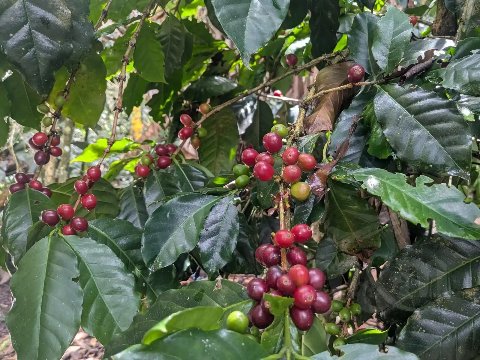
The next day continued with the descent. Mapy.cz promised a path that was only downhill, but reality was different – the constant “up and down” was quite exhausting. We reached Lucmabamba, where we exceptionally had reserved accommodation – a coffee farm with a tour looked very interesting and had great reviews, so we felt it would be a shame to miss it. Our host, Freddy, showed us the whole process from picking the berries to drying and roasting. At the end, he brewed us such a strong coffee that, despite our fatigue, we had a bit of trouble falling asleep. It was worth it, even though it was a slightly more expensive accommodation than we would normally look for.
Day 4: First glimpse of Machu Picchu
In the end, though, we were glad to be sleeping under a roof. It rained hard during the night and the rain continued into the morning. All of us staying at the coffee farm sat at breakfast with no motivation to go outside. We didn’t really want to head out. Freddy reassured us that it would stop at ten, and he was right.
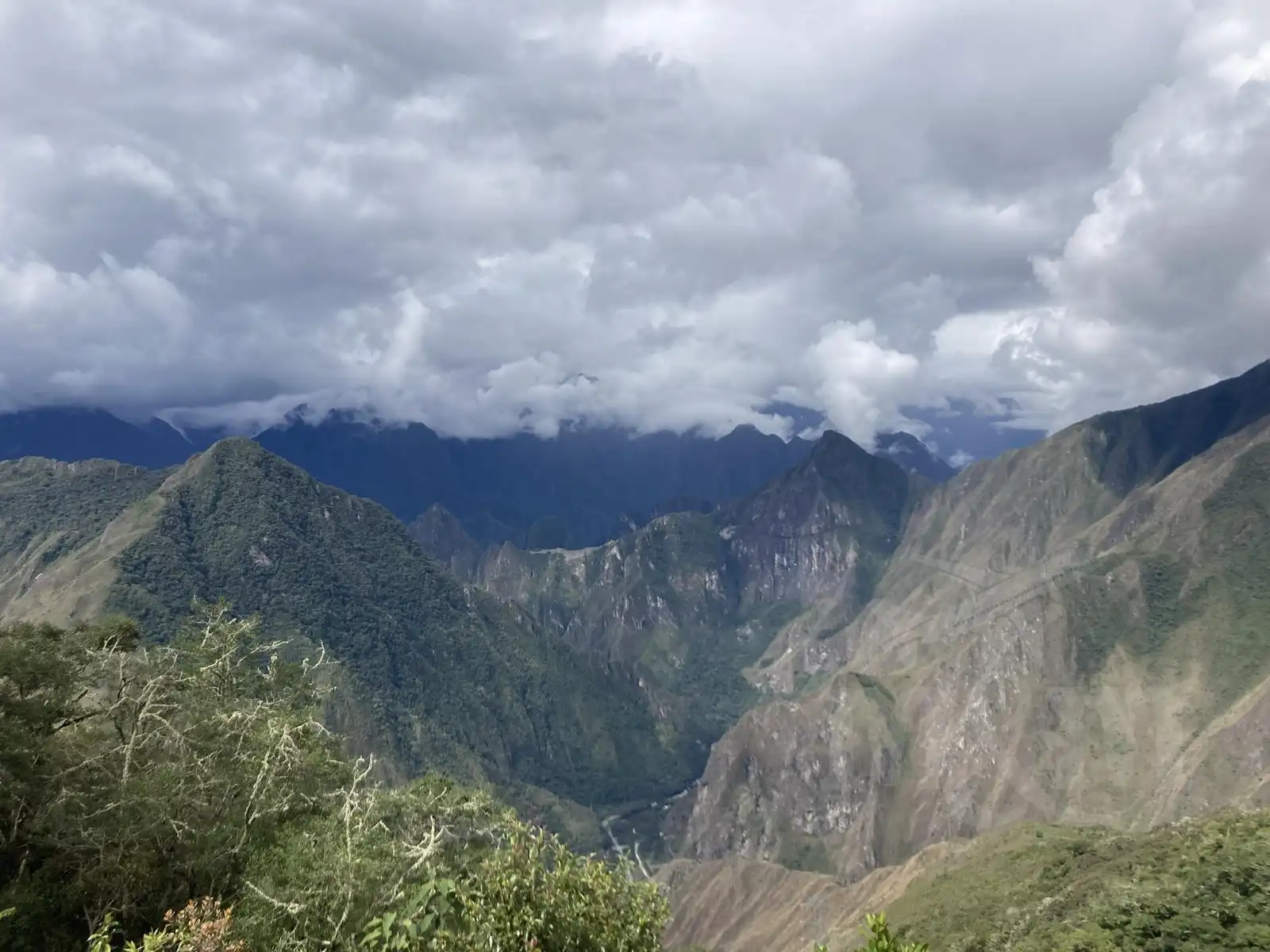
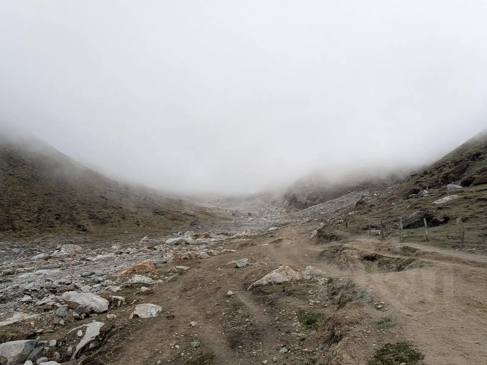
Ahead of us was the climb to the Llactapata pass. After the rain, the path was one big mud pit, which caused some tourists to give up and take a taxi to Santa Teresa instead. Thanks to that, however, we were almost alone on the trail. We climbed to the top of the hill and the reward was worth it: the sun was shining and on the opposite hill, we saw Machu Picchu for the first time.
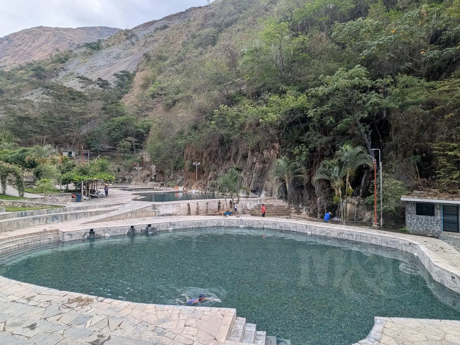
On the hill, we caught up with a Czech-Slovak couple, with whom we took a detour to Santa Teresa (we took a taxi from Hidroeléctrica), where we spent the evening and the following morning in the Cocalmayo thermal baths. It was ideal for our tired legs.
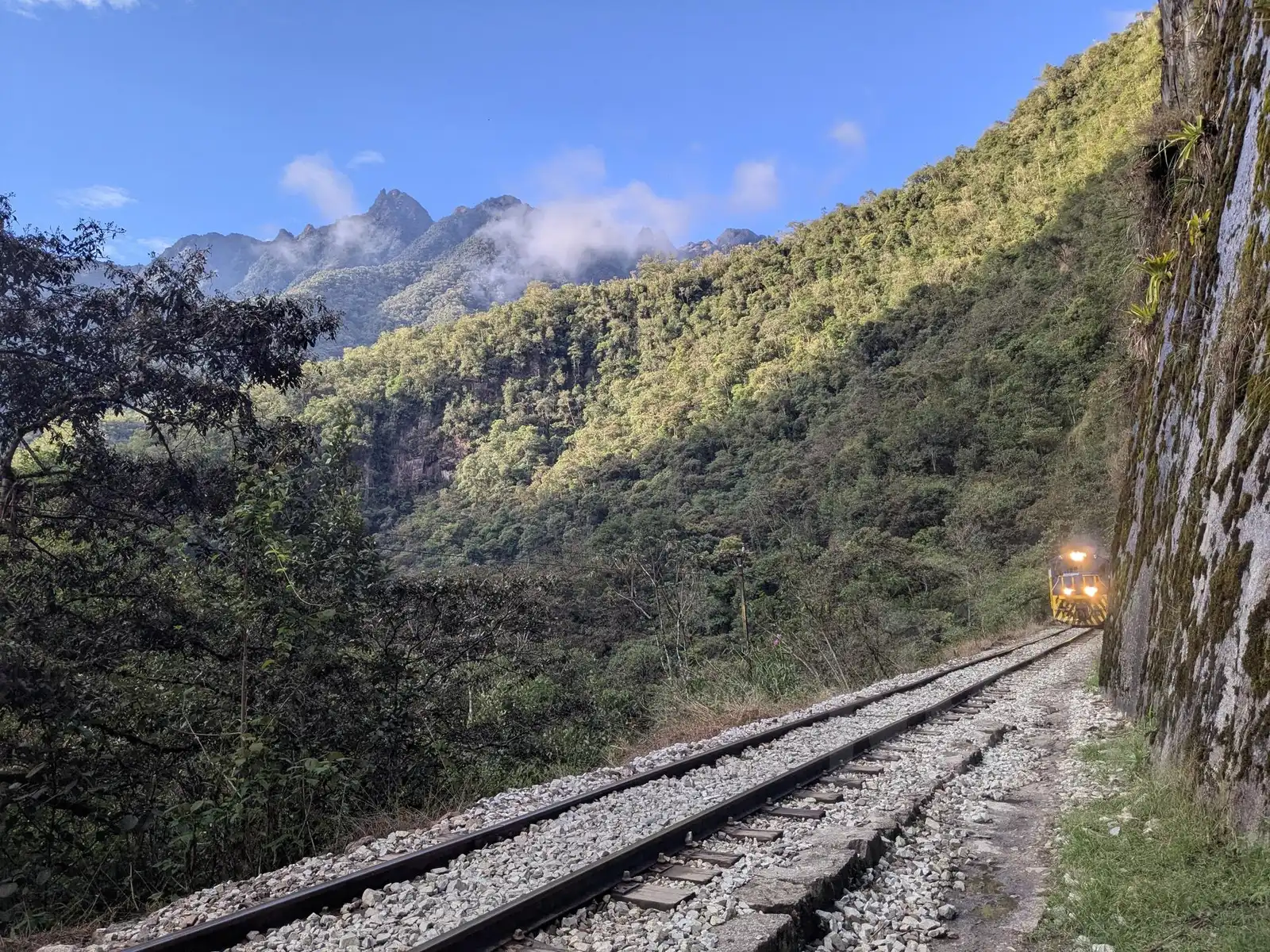
Day 5: The path along the tracks and Aguas Calientes
After a morning visit to the baths, we found a colectivo that took us back from Santa Teresa to Hidroeléctrica. From there, only the last 10 km on foot along the tracks to Aguas Calientes remained. The path leads through the jungle on flat ground, but in the heat and humidity, it felt endless and a bit boring. Occasionally a train passes, but it moves very slowly and can be heard from kilometers away.
Aguas Calientes itself (also known as Machu Picchu Pueblo) is a town built purely for tourists. While I found it ugly and unauthentic, Magda, after days in a tent, enjoyed the “Western” standard of accommodation with a hot shower and a comfortable bed.
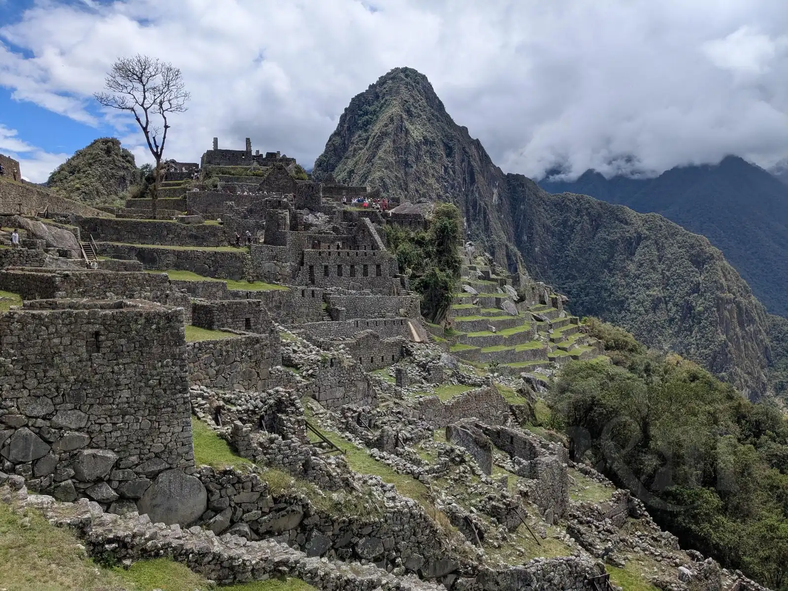
Day 6: Machu Picchu
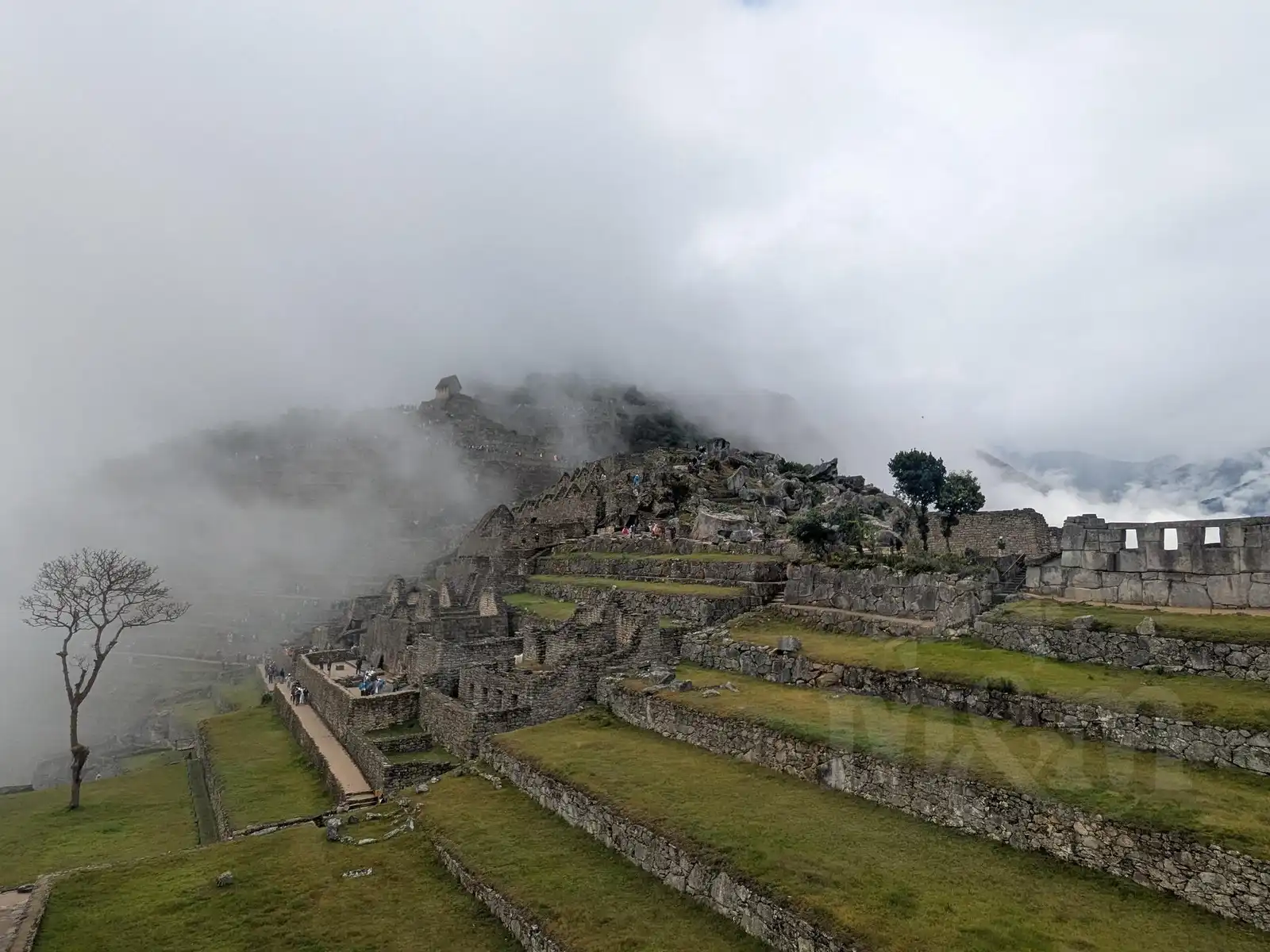
We had our Machu Picchu tickets reserved for the first slot at 7:00 AM. Machu Picchu is on a hill above Aguas Calientes, which you can reach on foot (but it’s 500 meters of elevation gain) or by tourist bus (but it’s quite expensive, 12 USD one way). We didn’t want to get up at 5:00 or earlier, so we chose the bus. When we stepped out of our accommodation, it was pouring rain, so we were glad we didn’t have to climb up a muddy hill. We were afraid we wouldn’t see much from Machu Picchu.
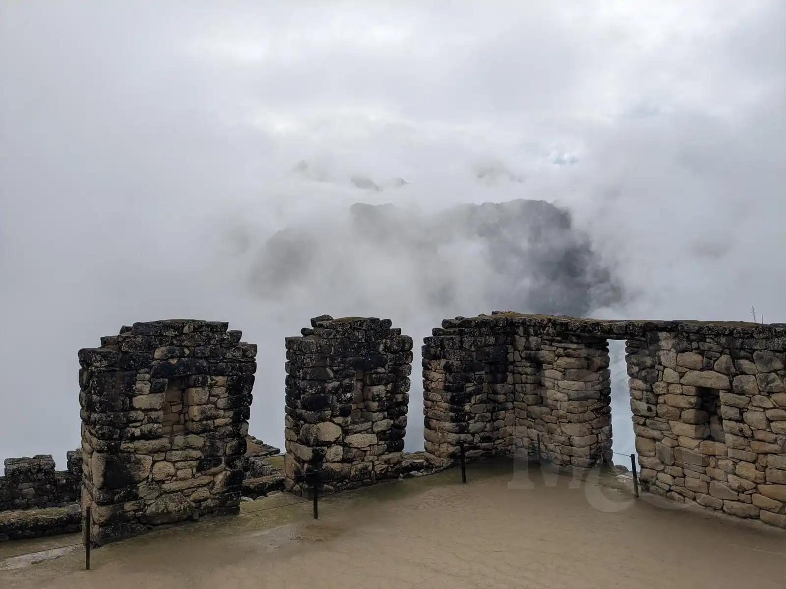
But as we passed through the gate, a miracle happened. The rain gradually stopped and Machu Picchu slowly emerged from the fog before our eyes. In the end, that was perhaps even more impressive than if it had been sunny the whole time.
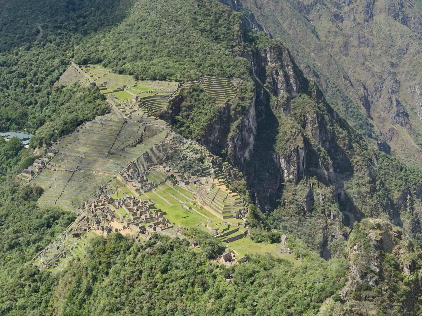
We had a circuit combined with a climb up Huayna Picchu mountain. The hike was brutally steep, but the view of the Inca city from above was indescribable. In the end, we told ourselves that despite the crowds and the high price, it was definitely worth it. We spent four hours up there and left absolutely amazed.
We walked back down to Aguas Calientes, as we didn’t want to pay for the bus again. On the way, we also stopped at the museum at the bottom of the hill, which is included in the price of the Machu Picchu ticket (but not many people seem to visit it; it was almost empty). It’s interesting, explaining the discovery of Machu Picchu and why it actually stood there.
The Return
In Aguas Calientes, we picked up our luggage and returned along the tracks to Hidroeléctrica. We had a minibus back to Cusco (we didn’t want to pay for the train), but not until the next day – minibuses to Cusco usually depart around 2 p.m. and we didn’t want to rush at Machu Picchu. So, one more night in a tent at a campsite awaited us. Mandor campsite, about halfway, was cheap and quiet. The next day, we reached the minibus and what followed was a six-hour, quite bumpy journey over mountain passes back to Cusco. We were tired and dirty, but happy.
Ausangate
Originally, we planned to take just a short rest after the Salkantay Trek and then head out for a four-day circuit around Mount Ausangate. It was supposed to be one of the highlights of the trip – a route leading past glaciers and turquoise lagoons. However, after returning from Machu Picchu, fatigue set in, and with it, doubts. Additionally, the start of the rainy season was approaching, and we learned that the highest sections of the trek (over 5,000 m above sea level) could be covered in snow. We had neither the equipment nor the desire to wade through snowdrifts. After much consideration, we decided on a “light” version: choosing the two most interesting sections as separate trips.
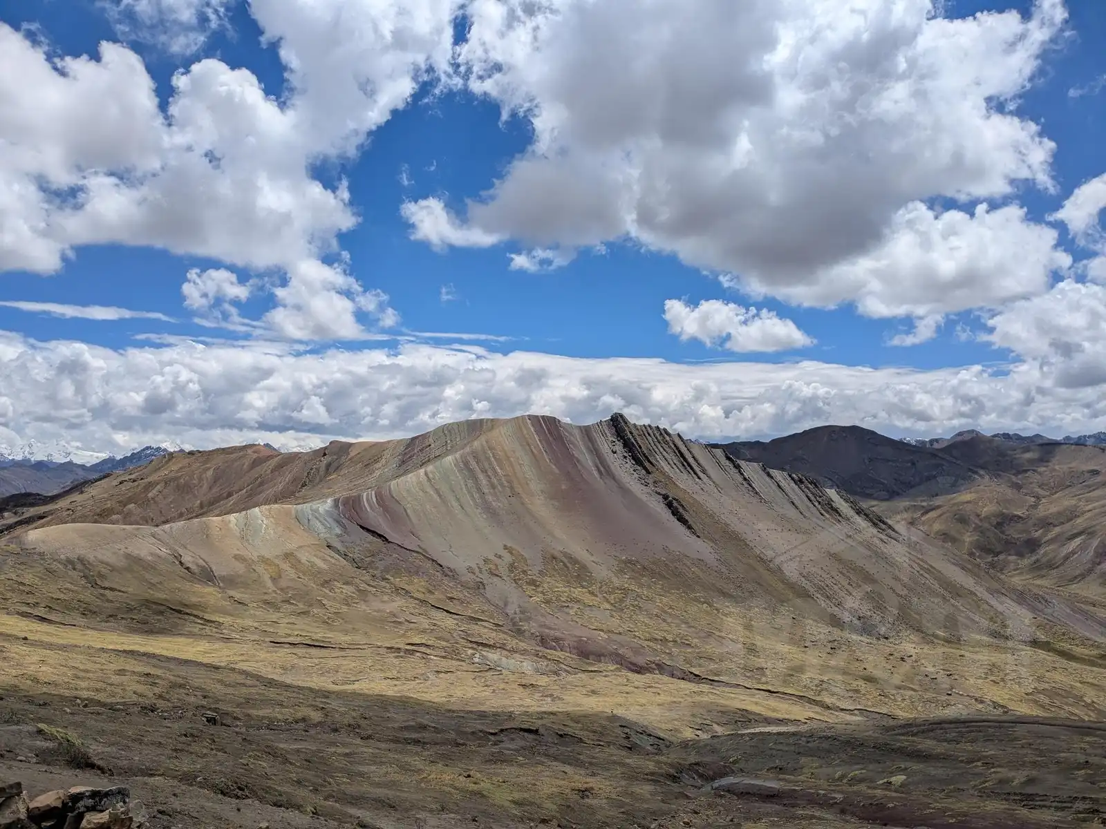
Palcoyo Rainbow Mountain
We wanted to see a Rainbow Mountain, but the over-hyped Vinicunca didn’t appeal to us much. It is the second most visited place in Peru, which means crowds of people and high entrance fees—not exactly the attributes we look for. Furthermore, almost all tours depart at the same time, so everyone gets there at once. Fortunately, we discovered an alternative – Mount Palcoyo.
We booked a tour there with Machu Picchu Reservations and were satisfied. The drive to the mountain is long, but there are stops for breakfast and lunch along the way. From the parking lot, it’s just a pleasant walk through a colorful “Martian” landscape with views of three different rainbow mountains and a stone forest. After a demanding week, a more relaxed trip was more than welcome.
7 Lagoons Circuit
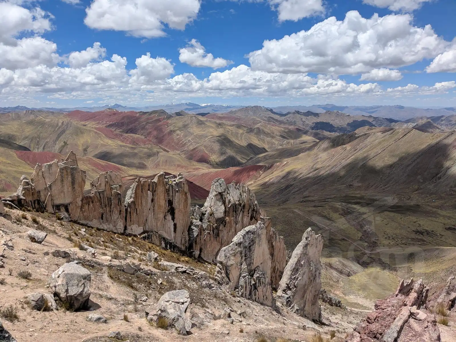
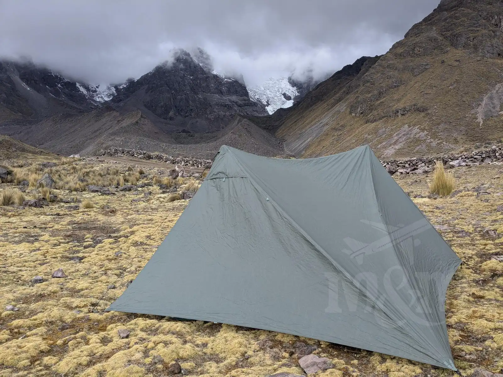
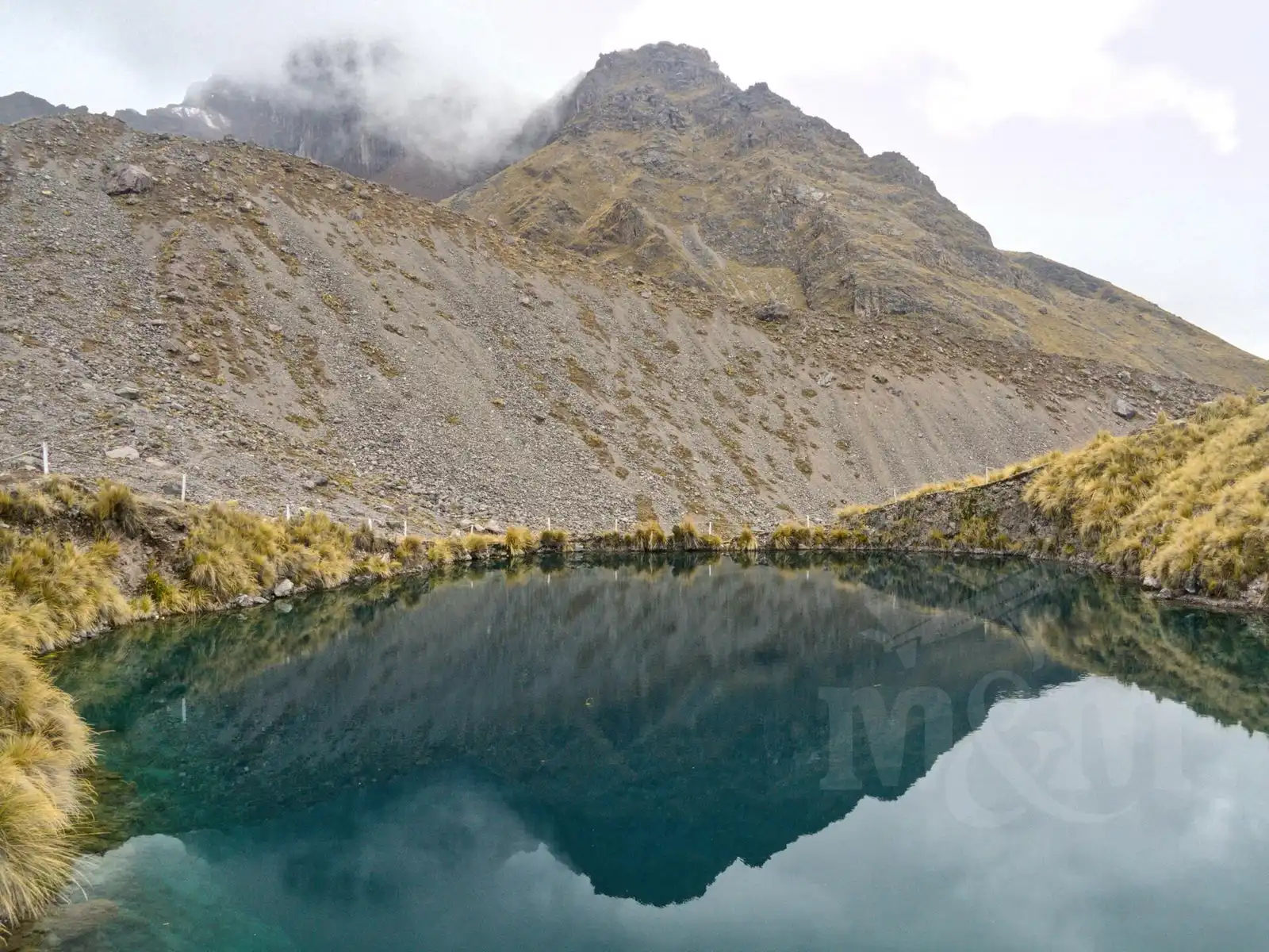
As a second trip, we chose the seven lagoons circuit, which usually concludes the Ausangate trek. We took a local bus to the village of Tinki and from there a taxi to Pacchanta, where there are thermal baths. However, we saved the soak as a reward for the end. We put on our heavy packs and headed uphill. We set up our tent just before dark by the Azulcocha lagoon at an altitude of around 4,300 m above sea level. It was our highest overnight stay. It was quite cold at night, but fortunately, we had packed good cold-weather sleeping bags.
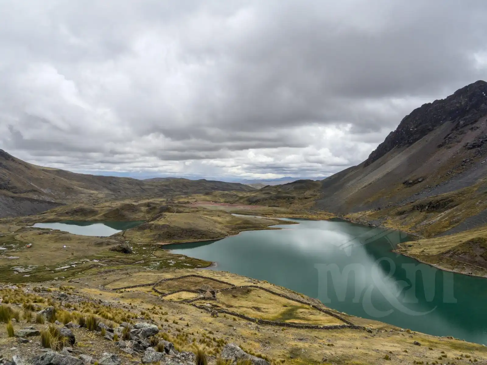
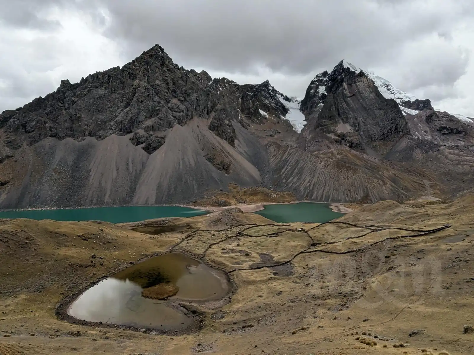
In the morning, a tour of the lagoons awaited us. There are definitely more than seven of them, and each has a different shade of blue or green. We didn’t want to just follow the crowd, so we extended our route up to the pass and circled the mountain from the other side, where organized expeditions don’t go. The beautiful views there are countless.
We were already returning to Pacchanta, picturing ourselves in the thermal baths, when the sky clouded over and a heavy rain began, turning into hail within moments. Despite all our waterproof layers, we were soaked in no time. We literally ran to the baths, but in this weather, we had no desire to go for a swim. We took shelter under a roof, where one of the locals offered us a ride to Tinki. We gladly accepted. Fortunately, we didn’t wait long in Tinki and hopped on a bus to Cusco. We were glad to be sitting (and that our clothes were drying), but the bus was really slow and stopped everywhere, and the journey took about 5 hours. We booked accommodation while on the bus, took an Uber from the bus station, and after a quick shower, we were happy to crawl into bed. It was a beautiful trip, but quite demanding at the end due to the weather.
After this rainy experience, we had only one last day left in Cusco. We walked through the markets and, as a reward for the hardships we’d endured, treated ourselves to pizza in the evening. The weather was already making it clear that we should pack up – it rained for hours, and the rainy season was announcing its arrival in full force. We heard that such weather could last for the next several months. Since we had enough of the cold and high mountains, we decided for a radical change. Our next steps will lead us to the Amazon rainforest!
Practical Information (2025 prices)
- Tickets: For most monuments around Cusco, you need the Boleto Turístico Cusco (BTC). You can’t buy individual tickets for single sites – so without the BTC, you simply won’t see anything. There is a 10-day version covering all circuits and monuments (16 sites) for 130 PEN (approx. 38 USD) and a 2-day version covering only one circuit/area for 70 PEN (approx. 20 USD).
- Machu Picchu Tickets:
- Not included in the BTC (obviously 😉).
- The price is high, 200 PEN (approx. 60 SD) per person for foreigners—depending on the chosen circuit. For foreigners, it is several times more expensive than for locals; just accept it.
- Tickets (at least in high season) need to be reserved online several months in advance. If they are no longer available for your chosen date, not everything is lost; a limited number of tickets for the following day can be bought in person in Aguas Calientes. Apparently, this wasn’t a problem in the off-season. In high season, expect to have to stand in line in front of the ticket office from early morning and hope for the best.
- Besides the tickets, transportation is also expensive: train prices start at 60 USD one way; the minibus is cheaper at approx. 15 USD – but it’s longer and more uncomfortable. Buses between Aguas Calientes and the Machu Picchu gates cost 12 USD one way.
- Inca trail: If you want to do the multi-day Inca Trail to Machu Picchu, you need to book up to six months in advance, and expect prices to start at roughly 600 USD per person.